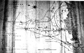
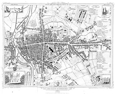
18. Anon / Alexander Jenkins 1806 A further illustration, also engraved for Alexander Jenkins´ History of Exeter of 1806. The plan is not signed and the lettering is of poorer quality than the city map. Title: A Plan of Rougemont Castle as described by LELAND in the 16 th Century Size: 157 x 104 mm with Scale of Yards 50 = 23mm. The title runs across the top in a frame and a panel of References is below what is a simple plan of the North East Corner of the City showing the Castle Precinct , the walls and the castle buildings. Note the County Goal , just outside the main gate. It is interesting to compare this ...
Posts
Showing posts from September, 2020
- Get link
- X
- Other Apps
19. Mutlow (Daniel Lysons) 1822 H Mutlow engraved maps for Cadell and Davies to illustrate Magna Britannia by the Reverend Daniel Lysons and Samuel Lysons . This work was very ambitious and planned as an updated improvement on William Camden’s Britannia (originally published in 1586 this was the classic volume on British history) and was produced in parts beginning with Beds, Berks and Bucks in the first volume dated 1806. Mutlow engraved many illustrations for Lysons volume on Devon (Volume VI) [1] including a copy of Braun and Hogenberg (3), a county map of Devon (B&B 89) and three maps of ports/rivers . He also engr...
- Get link
- X
- Other Apps
20. John Hayman (T and H Besley) 1828 Thomas Besley was born in 1760 and advertised himself as printer, bookseller and stationer or bookbinder and was listed in various directories of the time at Southgate Street (1801 and 1811); at Holy Trinity (1803); and at 76, Bell Hill, South Street (between 1816 and 1834). Thomas and Jane had 6 children including Thomas Junior (he became an independent printer in Exeter) and Henry who eventually became partner and successor to the family business. Few local printers published extensively but Henry Besley could claim to have been one of the most prolific of local publishers. It would appear that the Besleys were in contact with John Hayman (see 16) and managed to obtain the plates which had been used for his map of 1805. They...
- Get link
- X
- Other Apps
21. Hackett I 1830 Thomas Hackett (fl 1830-1844) set himself up as a lithographer in Exeter after his marriage in 1824 and by 1831 he had become Exeter’s principal lithographer working in Sidwell Street. He moved to Paris Street in 1834 and in 1840 founded his Lithographic Office in Magdalen Street. There he was joined by his brother William , a Captain of the Royal Navy, who later succeeded to the firm. Hackett produced the three plans described here in connection with the improvement of roads and turnpikes and a city plan to show the old and the new City Boundaries (see Dawson I). None of the plans below is dated and all ar...
- Get link
- X
- Other Apps
22. Wills / Hackett 1830 Title: PLAN OF The City of Exeter shewing the Lines of Road Proposed by Messrs. Coldridge & Vicars . Size: 355 x 245 mm but no scale. Imprints: W. Wills, Exeter and Hackett, Lithog. Exeter The plan shows two alternative routes proposed: Vicar’s line cut through the walls almost mid-way between North-gate and the Castle, joining the High Street south of the Guildhall; and Coldridge’s line came south of St. David's Hill and South-gate ending mid-way along North Street. Coldridge also had a branch outside the city to the London Inn (formerly the Oxford) just outside East-gate. This branch followed the line of the ‘west’ new road, first shown in Hayman’s plan of 1805. The end r...
- Get link
- X
- Other Apps
23. Hackett II 1830 Title: None but shows the planned new roads and a plan of the city of Exeter. Size: 386 x 295 mm with a Scale of Chains (1+15 = 65 mm). Imprint: HACKETT, LITHOG: EXETER . A slightly better plan showing proposed Barnfield Road to join the London Road at Summerland Place ( now forming ) and the New North Devon Road (from St. David's Hill to Longbrook Street). Return to Catalogue
- Get link
- X
- Other Apps
24. Robert Dawson I 1832 Lieutenant, later Lieutenant-Colonel Robert Kearsley Dawson , RE (1798-1861) was the son of Robert Dawson, a Devonian, who had been active during the first Ordnance Survey of Devon of 1809 (B&B 74). R K Dawson entered the Royal Engineers in 1818 and worked in Scotland under Thomas Colby , Superintendent of the Ordnance Survey. Dawson prepared the boundary surveys for 277 county maps and city plans of England and Wales which were printed as a result of the Reform Bill of 1831 and related to the Boundaries Act passed in July 1832. The maps and plans were subsequently published in two volumes in 1832. This map was number 38 i...
- Get link
- X
- Other Apps
25. Richard Creighton 1835 Samuel Lewis issued his A Topographical Dictionary of England in 1831 (B&B 103) which contained county maps inserted at the relevant section of the text. In 1835 he produced a new supplementary volume comprising a Representative History of England which contained county and borough maps showing the electoral boundaries and changes following the 1832 Reform Act . This made up Volume V to the third edition of Topographical Dictionary . The View of the Representative History of England was issued as a separate publication in 1835 and 1840 with a total of 116 maps. All the maps in this later work were dr...
- Get link
- X
- Other Apps
26. Brown / Schmollinger 1835 Little is known of W Schmollinger ( fl .1831-37) outside his work on maps for Thomas Moule’s English Counties (B&B 111). In an 1837 trade directory he is advertised as a specialist map engraver but little work of his is known. He had premises at 27 Goswell Terrace, Goswell Road, and later in Aldine Chambers, Paternoster Row. He may well have been the son of the Joseph Schmollinger and Mary Drew who married at St. Leonard Shoreditch in 1799 [1] . In 1836 Schmollinger engraved an attractive county map of Devon in a similar style to those in Moule’s English Counties . The frame, typical of Moule’s maps has columns right and left with two different and very ornate sto...