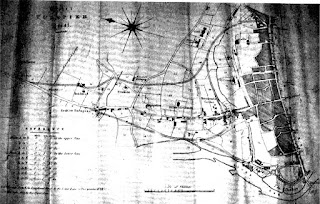
21. Hackett I 1830
Thomas Hackett (fl 1830-1844) set himself up as a lithographer in Exeter after his marriage in 1824 and by 1831 he had become Exeter’s principal lithographer working in Sidwell Street. He moved to Paris Street in 1834 and in 1840 founded his Lithographic Office in Magdalen Street. There he was joined by his brother William, a Captain of the Royal Navy, who later succeeded to the firm.
Hackett produced the three plans described here in connection with the improvement of roads and turnpikes and a city plan to show the old and the new City Boundaries (see Dawson I). None of the plans below is dated and all are from approximately 1828-32. They all include new, projected road routes which can be seen on later maps, e.g. Dawson (1832).
The company executed a great number of prints for Spreat’s Churches. Thomas also produced a number of estate plans of local properties, e.g. plans of Court Estate, Situate in the Parish of Dawlish, the Plan of Higher Hern Estate in Halberton (1835), his Plan of the Mansion House and Lands, called The Lodge (Tiverton, 1835) and his Map of Orchard Estate (also Dawlish, 1838).
Title:
Exeter TURNPIKE Trust.
Size: 290 x 450 mm with Scale of Chains (20 = 80 mm).
Imprint:
Hackett, Lithog Verney Place, Exeter.
There is a north point,
References (of distances) and a scale bar. The northern half of the city is
shown from High Street and Fore Street. The plan shows the proposed new roads
to the north of the city: Exe Bridge to Red Cow Turnpike; Longbrook Street to Belmont
through Elmfield and Taddifield; a link road, joining both, through Townsen's
Gardens. The City Prison, the County Gaol and the House of Correction (i.e. the
Bridewell) are shown (below has a view as published in Thomas Moore's History of Devonshire).


No comments:
Post a Comment