Posts

Showing posts from August, 2020
Image
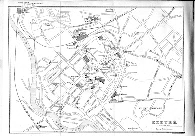
  41.     John Murray I                                                                            1863   The late 1830s had seen the introduction of the handbook or guide book and the prominence of the two publishing houses who would dominate the British market for guidebooks throughout the Victorian era: Murray ( Handbook ) and A & C Black ( Guide ). Murray´s first map of Exeter appeared as early as 1863 but it would not be until 1881 that A & C Black included a plan in their guide (49). John Murray (1778-1843) started the famous series of red-bound guides in 1836 but it was his son, also John, who produced the first county guide; A Handbook for Travellers in Devon & Cornwall was first published in 1850. The early editions did not include any town maps, but the 5th edition of 1863 included a map of Exeter. In the 9 th edition of 1879 the map was replaced by one by Edward Weller (see 48).   Title: EXETER Size: 125 x 100 mm but no scale. No signature and
Image
  42.     Henry James                                                                                   1868   In 1867 the Boundary Commission produced 196 plans of English Boroughs and 51 of Welsh Boroughs. Although the report purported to include each Borough and County , very few county or part-county maps were included. [1] Henry James (1803-1877) had overseen the initial stages of the later surveying of towns and boroughs in the West Country. He joined the Ordnance Survey in 1827 and became the Director-General in 1854, a post he held until 1875. James was a supporter of lithography and his enthusiasm for the new technique of photo-zincography led to it becoming a standard process in the production of Ordnance Survey maps. He became a Fellow of the Royal Society, was knighted in 1860 and promoted to Lieutenant-General in 1874. The boundary maps were prepared under the direction of Captain R M Parsons by lithographic transfer with overprinted colour representing the parlia
Image
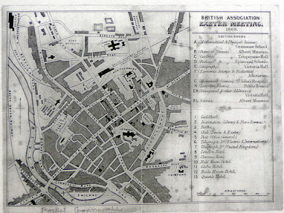
  43.     British Association                                                                                 1869   The British Association for the Advancement of Science was founded in 1831 on the lines of a German Institution. William Vernon Harcourt and J F W Johnston were leading advocates of the association in competition with the Royal Society. The first meeting was held in York but annual meetings were held in different cities; in 1869 Exeter was chosen. Although a guide of sorts may have been printed for attendees only a copy of a specially produced map has been seen by the authors and this has been loosely inserted into a copy of Murray’s Handbook for Travellers (1859) [1] . However it is highly probable that the map was issued to participants as part of a welcome pack or possibly together with the  Report Of The British Association For The Advancement Of Science Held At Exeter In 1869  which would have been presented or sold to each participant who had attended the
Image
  44.     Robert Dymond I                                                                    1873 (1773)   Robert Dymond’s book, History of the Suburban Parish of St. Leonard, Exeter was published in 1873. In it, Dymond included an up to date map of the city and also a similar map to show the changes since 1773. In 1882 he published a similar work on the Parish of St. Petrock.   Title: ST. LEONARD 1773 Size: 180 x 209 but no scale. Imprint:   G. Wolfenden, Lith, Exon   Shows the area from the Cathedral northeast to Liverydole and southeast to the site of St. James Priory bounded by Magdalen Road and the River Exe.[1] Return to Catalogue [1]   Illustration  reproduced by kind permission of Devon Archives & Local Studies -  . B/EXE/726.5/DYMr . Documents held at Devon Archives are copyright. Copying, printing, reproducing or sharing images of them on this website is not permitted
Image
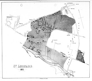
  45.     Robert Dymond II                                                                         1873   Robert Dymond’s book, History of the Suburban Parish of St. Leonard, Exeter was published in 1873. In it, Dymond included an up to date map of the city and also a similar map to show the changes since 1773 (see previous entry). In 1882 he published a similar work on the Parish of St. Petrock. Title: ST. LEONARD 1873 Size: 180 x 209 mm but no scale. Imprint:  G. Wolfenden, Lith, Exon   Shows the area east of the Cathedral as before but James Priory is now Old Abbey. Shows the extensive development in Mount Radford together with Topsham Barracks and the changes to the river (e.g. Trews Wear and Salmon Pool near Old Abbey).[1] Return to Catalogue [1]   Illustration  reproduced by kind permission of Devon Archives & Local Studies -  . B/EXE/726.5/DYMr . Documents held at Devon Archives are copyright. Copying, printing, reproducing or sharing images of them on this website is n
Image
  46.     Thomas Kerslake                                                                       1873 (925)   Thomas Kerslake (1812-1891) was born and educated in Exeter but moved to Bristol in 1827. With his brother-in-law he became a second hand bookseller. Although the partnership was dissolved in 1839 he continued in business and retired in 1870 after a disastrous fire. He then became interested in antiquarian studies, especially the Anglo-Saxon period of the south-west, and wrote a number of articles including one in 1890 about a fictional leader in Saxon southwest, Saint Richard the King of Englishmen . Strictly speaking this is the second printed map of Exeter as it purports to show the area covered by the Saxon mound with the early fortifications at Exeter imposed as it might have been in 925, 1286 and 1778 A.D. It was included in an essay presented by Kerslake to the Archaeological Society . Kerslake wrote about the old division of the City ‘ The Celt & Teuton in Exet
Image
  47.     George Washington Bacon                                                          1876   Edward Weller could not have imagined how long his maps (county maps, town plans and maps of the railway networks) would continue to be published when he executed them for the Weekly Despatch in 1858 (B&B 136). Issued first with that newspaper at regular intervals, they were bound into atlases published by the same company in 1863. Cassell, Petter & Galpin took over the plates and produced a variety of publications with the county maps. George Washington Bacon bought the plates c. 1868 and from 1869 to the early years of the twentieth century reissued the county maps in atlases, e.g. New Large Scale Ordnance Atlas of the British Isles , as well as producing folding maps for the burgeoning leisure industry. Devonshire appeared as two sheets in most of the atlas issues but could be found together or separated in covers as a folding map. In one of these single sheet county ma
Image
  48.     John Murray II                                                                                    1879   So popular were John Murray’s red-bound books that the company separated Devon & Cornwall in the 9th edition of 1879 and introduced a new, and considerably improved, map for Exeter (replaces 41) for the Devonshire handbook. The plan was used in the Tenth (above) and Eleventh Editions of Murray’s A Handbook for Travellers in Devonshire until 1901.   Title: EXETER for Murray’s Handbook for Devon Size: 160 x 190 mm but no scale. Signature: Edwd Weller (engraver) and publisher’s imprint: London: John Murray Albemarle St.   The plan covers the area from St. Thomas to Polsloe Park and from the Canal Basin to Exwick. It is the first map to have a grid system to aid finding locations. Although rather a small map it is accurate and detailed and would have been a useful aid to the traveller. Revised copies of the plan were used in the later 10 th edition of 18
Image
  49.     A & C Black / Bartholomew                                                       1881                                                                   Adam Black (1784-1874) started the Edinburgh firm in 1807, his nephew Charles not joining the firm until 1833. Their first Scottish guides appeared in 1839 and in 1843 they published their first Guide to England and Wales. The first guide to the southwest appeared in 1855 with a new, completely revised edition, appearing in 1862 (Devon with Cornwall and Dorset). However, the Devon text was extracted and used concurrently in Black’s Guide to Devonshire . From the 12 th edition of Black’s Guide to England and Wales (1881 above) and the 11 th edition of Black´s Guide to Devonshire (1882) a map of Exeter was included. Apart from the size the two maps were virtually the same. Though only acknowledged in the former work the map was executed by John Bartholomew of Edinburgh.   Title:   EXETER Size: 90 x 140 mm with Sc
Image
  50.     Cassell & Co. Ltd I                                                                     1882   Our Own Country ... Descriptive, Historical, Pictorial was produced originally in 1882 (two volumes in a five-volume set are dated) and sometime later also for subscribers in 6 volumes. There were five maps in total covering Devon, each set in a page of text in the various volumes. The maps are: Map of the Course of the Plym, Map of North Devon, Map of South Devon, Old Plan of Exeter (a small copy of Braun & Hogenberg ) and Map of Exeter. Although the volumes are packed with maps and plans, many have no scale and only maps in the fifth volume of the early set had a printer’s signature. All maps are very small with little detail. Cassells also published J R Chanter ´s Lundy Island complete with a map of the island possibly executed by Chanter himself and a further map of Exeter was published in their guide to the L&SWR in 1888 ( 57 ).   Title: MAP OF EXETER. S
Image
  51.     Alfred Vincent                                                                            1884   The following map can be found in a guide published by Alfred Vincent , a local printer and publisher: Vincent’s Guide to Exeter . Alfred Vincent published this guide in 1884 but by 1889 Mrs Alfred Vincent was carrying on the business as lithographic printer at 1 Maddocks Row and was still in business at the same address in 1893.   Title: GROUND PLAN OF EXETER Size: 192 x 252 mm but no scale. Imprint: A. Vincent, Exeter Lith.   This is a simplified street plan showing prominent buildings (some of which are drawn in elevation, e.g. St. Michael’s Ch.). The drawing is rough, inaccurate and sometimes misleading even though it shows nearly all the important buildings. It is interesting to note that some place names are upside down, the Catholic Cathedral at Palace Gate, the Ferry at Quay Lane, the incorrect railway siding in to the Basin and the complete absence of the city
Image
  52.     Dulau / Bartholomew                                                                  1884   The Dulau company began their famous Thorough Guide Series in 1882 (North Devon and Cornwall) and 1884 (South Devon and Cornwall, illustrated above). The editors (and probably authors) were M J B Baddeley and Charles Slegg Ward, hence the series became known as the Baddeley & Ward series. Mountford John Byrde Baddeley (1843-1906), a school master, earned his reputation as the compiler of these Thorough Guide books for pedestrians . He settled in the Lake District which he popularized as a pleasure resort. According to the advertising text in the guides: In English topographical writing for tourists, the Thorough Guide Series is so far ahead of any other that there can scarcely be said to be a good second to it . ( Saturday Review , August 28 th , 1886). The Times (August 3 rd , 1887) even went so far as to compare a Baddeley with a Baedeker . A cursory glance at the con