26. Brown / Schmollinger 1835
Little is known of W
Schmollinger (fl.1831-37) outside his work on maps for Thomas Moule’s English Counties (B&B 111). In an
1837 trade directory he is advertised as a specialist map engraver but little
work of his is known. He had premises at 27 Goswell Terrace, Goswell Road, and
later in Aldine Chambers, Paternoster Row. He may well have been the son of the
Joseph Schmollinger and Mary Drew who married at St. Leonard
Shoreditch in 1799[1].
In 1836 Schmollinger
engraved an attractive county map of Devon in a similar style to those in Moule’s English Counties. The frame, typical of
Moule’s maps has columns right and left with two different and very ornate
stonework patterns between. The map was published by R Colliver of Exeter of whom nothing is as
yet known. It has Colliver’s imprint, is dated 1836 and has been inserted into
editions of The History of Devonshire from the earliest period to the present by Rev. Thomas
Moore. Illustrated by a series of views drawn and engraved by and under the
direction of William Deeble.
The History was issued as a part-work and was advertised in other publications.[2] The work was published in London by Robert Jennings, 62 Cheapside, and the first issue appeared on September 1, 1829. Surprisingly, Henry Fisher began to publish his part work, Devon & Cornwall Illustrated, on exactly the same day.
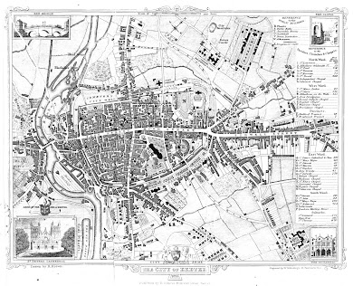
The first part issue (about fifty numbers were planned) contained the title page, two engravings and twenty-four pages of text which, apart from the extra title page, was the expected format. Although all the promised plates had been issued by 1834 in the initial 47 Numbers there were delays in printing and publishing the last 300 pages as evidenced by the dates in the two maps. These two maps (Devon and Exeter), both promised in the initial Mode of Publication printed on each part, were then added by the binder when the volumes were bound. The book was usually published in two volumes; the second volume having this town plan of Exeter, by Brown and Schmollinger, and also published by Colliver and similarly inserted. The work was also bound in three parts: parts one and two with the text; volume 3 being the engravings.[3]
Title: THE CITY OF
EXETER 1835[4]
Size: 185 x 245 mm with Scale of 1000 feet = 35mm (or 1 Mile =
185 mm).
Signature: Drawn by R.Brown.
Imprints: Engraved by W. Schmollinger, 13. Paternoster Row. (right) and Published by R. Colliver, Holloway Street, Exeter (central).
The City Arms and supporters are centre bottom, the Bishops Arms bottom left and a North point, top centre. There is a small vignette in each corner: Exe Bridge, The Castle, The Guildhall and St. Peters Cathedral. The two references show Public Buildings and Churches (etc.). The area shown is from St. Davids to St. Leonards and from Cowick Street to Black Boy Road. Two new roads are clearly shown for the first time (but see also 20): the New Road from Bedford Precinct to join the London Road at Summerland Place; and the New North Road from Longbrook Street to form a triangle at Pound Lane. There is also a small portion of new road at the end of Paris Street. This map shows the line of the recently built Higher Market Street from the High Street past the prison and out to the New North Road. Rocks Lane has now become Coombes Street. All wall gates are gone as are the inner castle walls (except the Norman gate tower). Progress has been made on the new development between Sidwell Street and Paris Street and along both Magdalen Road and Holloway Street: note, too, the Gas Works on the Bonhay, the new City Reservoir behind Danes Castle and the Coal Wharfs alongside the New Basin. The key lists a number of newer public buildings such as the Athenaeum, opened 1836, and the Episcopal Chapel (1832) near Bedford Crescent. Only two areas remain marked as Rack Fields.[1]
Laurence Worms; Some British Mapmakers; Ash
Rare Books Catalogue and Price List; 1992.
[2]
Part XXXIX of Moule’s English Counties
(111) contained an advertisement for
the various parts of Vol. I of Moore’s work. See Tony Campbell; The Original
Monthly Numbers of Moule’s ‘English
Counties’; The Map Collector; Issue
31; June 1985; p.31.
[3] For a full discussion on the probable publication history of Moore's History see my blog Two Rival Illustrated Works on Devon, 1829.
[4] The
only known copies have been bound into Moore’s
History of Devon, with title page still dated 1829 but the county map is dated 1836.


No comments:
Post a Comment