33. Jewitt – Agricultural Show I 1850
In 1850 Exeter played
host to the Royal Agricultural Show from Thursday 11th July to
Friday 19th July, 1850. This was a prestigious event, sure to attract large
numbers of influential visitors and two guide books were specially produced for
the meeting. There were two main show grounds and the meeting was expected to
attract between five and six thousand members.
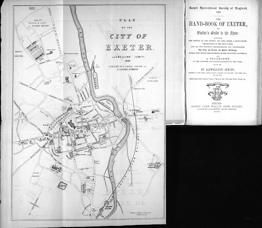
In 1850 he wrote a guide to Exeter for the Royal Agricultural Society of England which was published to coincide with the event, Royal Agricultural Society of England, 1850 ---The Hand-Book of Exeter . . . and a programme . . . by Llewllynn Jewitt . . . Exeter Henry John Wallis, High Street . . . MDCCCL. This was Jewitt´s fifth guide to the annual shows and the publishing schedule must have been tight as the Preface is dated July 1st, 1850. The volume included an extra plan of the show yards signed by Jewitt (L Jewitt Delt) and printed by Maddock & Balderston of Plymouth. Two further works by Jewitt on Plymouth contained maps: The Illustrated Handbook appeared in 1865; and Jewitt’s own History of Plymouth of 1873, initially started to supplement the notes left by Edward Nettleton on his death, contained two facsimiles of earlier maps of Plymouth by Wenceslas Hollar and the Lysons (c.f.). He drew a plan of Exeter Cathedral for Murray’s guide to Devon and Cornwall.
Title: PLAN of the CITY OF EXETER. Llewellyn Jewitt. 1850.
Size:
310 x 220 mm but no scale.
Imprints: Published by H. J. Wallis, Exeter, and R. Lidstone, Plymouth and below the title Maddock & Balderston, Lithographers, 17, Bedford St. Plymouth.
North is unusually to the bottom
giving a turned look to the city. It
is an open street plan from St. David’s Railway Station (Red Cow Village) to Topsham Barracks
and from St. Thomas to Sidwell Street. Primarily drawn for visitors, the plan
naturally illustrates the show yards east of Mount Radford, next to Veitch’s
Nursery, and most of the inns and hotels. Noteworthy inclusions are St.
Thomas’s Union Workhouse, St. Thomas’ station, and the Cattle Market just west of the bridge.


No comments:
Post a Comment