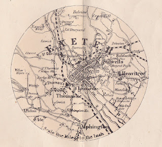
47. George Washington Bacon 1876
Edward Weller could not have imagined how long his maps (county maps, town plans and maps of the railway networks) would continue to be published when he executed them for the Weekly Despatch in 1858 (B&B 136). Issued first with that newspaper at regular intervals, they were bound into atlases published by the same company in 1863. Cassell, Petter & Galpin took over the plates and produced a variety of publications with the county maps. George Washington Bacon bought the plates c.1868 and from 1869 to the early years of the twentieth century reissued the county maps in atlases, e.g. New Large Scale Ordnance Atlas of the British Isles, as well as producing folding maps for the burgeoning leisure industry. Devonshire appeared as two sheets in most of the atlas issues but could be found together or separated in covers as a folding map. In one of these single sheet county map issues, circa 1876, a small inset map of Exeter was introduced.
Title: EXETER (written over map area)
Size: 96 mm diameter
with Scale One Mile to the Inch.


No comments:
Post a Comment