Monday, 10 August 2020

 59.     John Hooker / Reynolds I                                                          1892 


Herbert Edward Reynolds, a local historian and author of a short history of the diocese, edited a number of items from the Cathedral Archives including some plans and writings by John Hooker and brought them to the attention of a wider public in his An Original Manuscript Of John Hooker, Chamberlain Of The City Of Exeter 1555. This was published in 1892 and included illustrations of two of John Hooker’s manuscript plans made 300 years earlier.[1] Reynolds’ book included a Preface from Hooker’s ‘Great History of Exeter’now in the Guild Hall of the same City Written by his own hand, and never before printed – and included descriptive notes and an introduction. Hence, although John Hooker’s original manuscript plan was executed in 1590 it was not until 1892 that the plan of St. Sidwell´s (below) or the Churchyard (next entry) were first printed.

Though there is no actual title to the plan described below there is text written within a rectangle which describes the limits of the Fee ‘And so forth by the middle of ye same waye to a lile water there called Shyttebrooke, And downe by ye midle of the same brooke unto ye Southe ende & corner of a garden of ye sayde Prior of St. Johns adioynante yto the same brooke wch garden lyeth in the West Syde of the same brooke and within the soyle Fee & ground afore sayde. And so from ye same South ende & corner by and by dytch of ye same garden into a pathe westewardes lyinge betwene ye landes called St Johns  feeldes on ye one partie, and ye Soyle Fee & ground aforesayde on the other partie. And so forthe in the same pathe westewardes unto a close of William menardes. And so by ye  midle of ye same close over the close sometimes of Roger Golde in y southe partie and ye barne of ye sayde Thomas Bernes ats Renolde in ye north partye And so out into the high waye called Croldich waye, And so forth by ye midle of ye same waye Northwards betwene ye garden and tenement of John at Forde in the west parte into ye high waye cominge from Exeter to St Annes Chappell &c.’ 

Title: No title but shows the area of St. Sidwell’s Fee

Size: 260 x 285 mm. A compass (top) but no scale. 

The plan shows the Fee of St. Sidwell, part of the castle and the city walls from the east gate round to the south gate. Features of note include the Guildhall[2] at the corner of Paris Street; the doorway through the wall into the close; the Alms houses; three county stones; and St. Karlet’s Cross.

In 1911 William Pollard published An Account of the sieges of Exeter by John Hoker – transcribed by William J Harte. This work contained other plans executed by Hooker usually with his imprint: William Pollard & Co. Ltd. Lithographers, Exeter & London.

Return to Catalogue

[1] The original drawing and that of the churchyard are part of the collection of Hooker manuscripts formerly held by the Dean and Chapter as D&C.Ex.3530 f.37 and D&C 3530 f.59-60. They are now lodged at the Devon Record Office. Both maps are listed in a Table of Contents to Hooker's history (ECA Book 52) but the maps have no titles: Platt of St Sidwells Fee; and A Platte of the Churchyarde.

[2] The courts of the Lords of the Fee were held in this guildhall.

Sunday, 9 August 2020

60.     John Hooker / Reynolds II                                                            1892 


The second plate included in Reynolds’ work. For source, see previous entry.


Title: No title but sketch plan of the Churchyard

Size: 228 x 290 mm but there is no scale.

 The second plan is a drawing looking south east showing the precinct and the north east corner of the city. At the top are four coats of arms: The City, The Royal Arms, the eagle of the first Earl Redvers or Rivers and the Bishop's crossed keys. Hooker's own arms are at the bottom.


Return to Catalogue

Friday, 7 August 2020

 61.     Pollard – Church Congress                                                       1894


Thomas Pollard is believed to have first started business as a printer in Exeter in 1791.  Details are sparse, but he was probably using letterpress to print stationery, account books, and advertising pamphlets. In the early 1800s William Carss Pollard is known to have continued the family’s printing trade from a factory in 39/40 North Street, Exeter and like most printers at the start of the Victorian era provided whatever their clients requested – from advertising posters to timetables and letterbooks.

During the Victorian era and into the early 20th century the business grew substantially under the leadership of William Pollard (son of William Carss) and then his son, Herbert Pollard. They outgrew the premises on North Street and in 1919 opened an impressive new factory at Bampfylde Street. The depression of the 1930s was very tough and during the Second World War trading virtually ceased. On the 4th of May 1942 the factory was completely destroyed in the Exeter Blitz. The company’s insurers would not fully cover the claim and after the war the company had to be rebuilt largely from scratch and the company was gradually rebuilt through the 1950s and 60s. When the country’s largest manufacturers of weighbridges, Avery and Weightron, were frustrated with the quality of tickets supplied for their machines the Pollard company created a specialised production centre to focus on this market and are the undisputed market leader of weighbridge tickets today.[1]

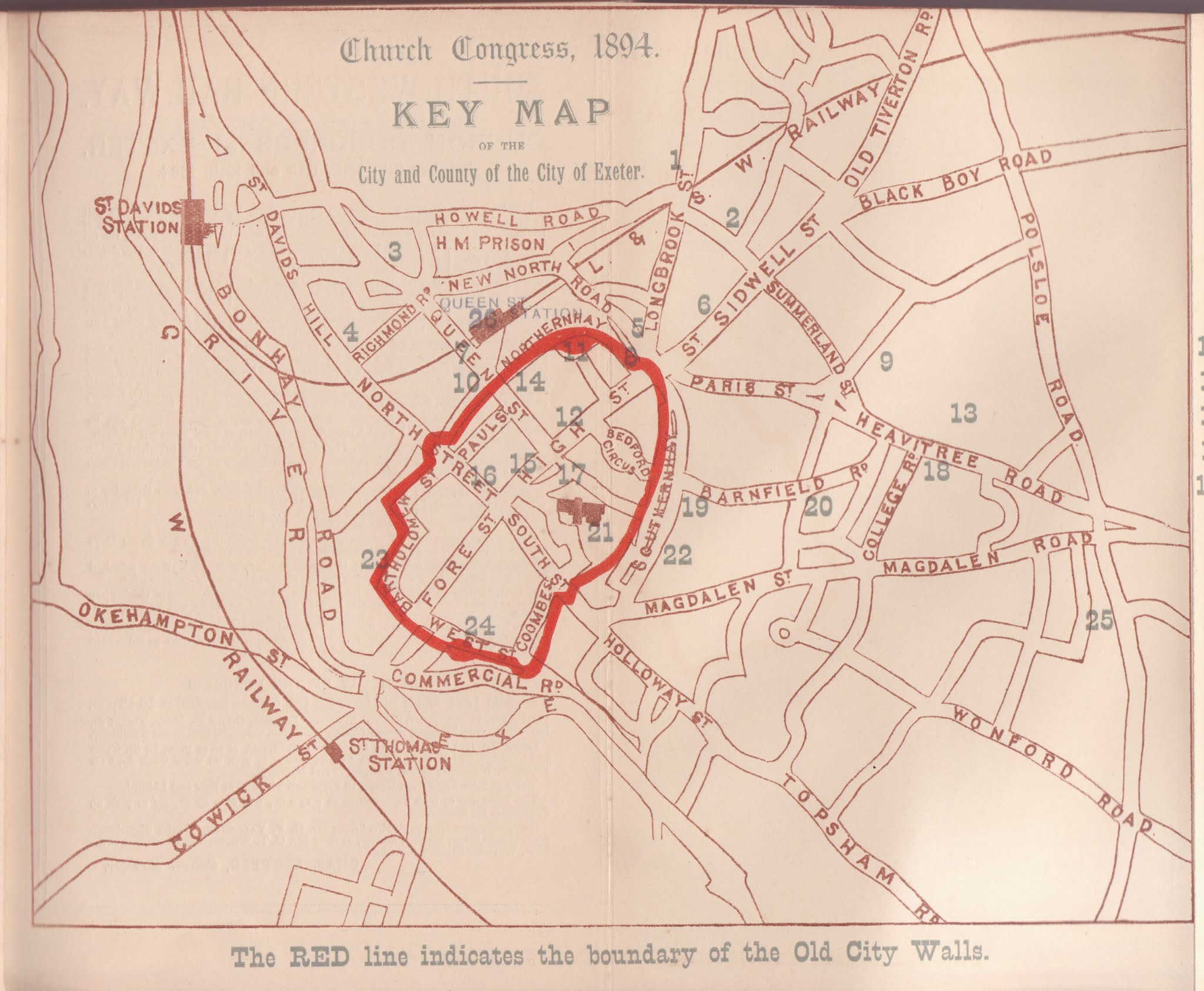
Although the cover title to the work below is Pollard’s Official History and Guide to Exeter it is clear from both the map itself and the paragraph of comments on the reverse of the map that this booklet was produced for the visit of the Church Congress which took place in October 1894.

Title: Church Congress, 1894. KEY MAP OF THE City and County of the City of Exeter.

Size: 170 x 213 mm but with no scale.

No signature or imprint. 

The plan has a type-script panel to the right (forming the third of three folding leaves) which refers to the numbers on the plan, and the use of certain buildings for the Congress. A simple plan of Exeter, only of interest for the congress, with the old city wall line marked red with note to that effect below the map; The RED line indicates the boundary of the Old City Walls. The right panel on reverse has information for those attending the congress on rail tickets.

Return to Catalogue

[1] Taken from the Pollard website at: http://pollardsprint.co.uk/history.html.

Thursday, 6 August 2020

62.     Walker & Boutall                                                                          1895 


In 1895 the Black’s fully revised their 15th edition of the Devon Guide (illustrated, see also 48). It was edited by A R Hope Moncrief and included a new and clearer plan of the City although still covering the same area. Published in Black’s Guide to Devonshire from the 15th edition. 

Title: PLAN OF EXETER

Size: 95 x 82 mm with Scale 1/8 Mile  (¼ = 20 mm, or 1 Mile = 80 mm).

Imprint: Walker & Boutall sc.   

It is a simple and precise street plan with only main streets named, a North point, a scale bar and 12 numbered references below the map. The railways have the distinctive railway pattern with both the Great Western Railway and the London & South Western Railway with the tunnel by Queen Street Station, and the branch line to the Basin. The key has reference to the Electricity Works (14), i.e. the Rockfield Works in New North Road, built in 1889. The guide was reissued from 1898 with 24 references below the map (and added numbers in map, illustrated below) and with the Public Hall now Victoria Hall.

Wednesday, 5 August 2020

 63.     Ward  & Lock II                                                                          1898 


Ward and Lock´s original plan of Exeter (see 55 above) was obviously inadequate and in 1898 a new plan, drawn and engraved by George Philip and Son was included when Ward and Lock published their first guide dedicated to Exeter. This plan first appeared in A Pictorial and Descriptive Guide To Exeter published in London, New York, and Melbourne by Ward, Lock and Co., Ltd. There was a Second Edition in 1900. 


Title: PLAN OF EXETER above map centrally.

Size: 140 x 190 mm with a Scale of 1/4 Mile (1/4 = 31 mm).

Imprint: WARD, LOCK & Co LTD, WARWICK HOUSE, SALISBURY SQ, LONDON

Signature: George Philip & Son, London & Liverpool.

A simple map of the city centre from St. David’s Station and St. Thomas to the workhouse in the east. Only important and public buildings shown and no residential development. The new theatre at the junction of Longbrook Street and New North Road is shown (opened October 1886) and the Electricity Station built in 1889.[1]

Return to Catalogue


[1] Illustration reproduced by kind permission of Devon Archives & Local Studies - .sB/EXE/1898/NEW

Documents held at Devon Archives are copyright. Copying, printing, reproducing or sharing images from this website is not permitted without prior permission.


Monday, 3 August 2020

 64   W J SOUTHWOOD & CO.                                                           1899 


Towards the end of the century many flimsy guides must have been produced which have not survived. Many would have been similar to the guide presented here published and distributed by the owners of Cole's Bazaar, a shop selling toys and presents of every description. Officially Gardner's Guide to Exeter it is in many regards a vehicle for mass advertising. Even the front cover is more an advert for H E Randall, Limited, a boot seller trading under the name The London Boot Makers than a real guidebook.

The guide, with printed paper covers, is advertised With 13 Illustrations from Photographs, and a Street Map of the City and has 24 pages with adverts on both covers and the first and last double pages. The text may have been written by either Gardner or by the owners of Cole's Bazaar but was put together in 1899: a reference to the current member of parliament, Hon. Sir Henry Stafford Northcote states that he is now (1899) fifty-three years of age.

The illustrations embedded in the text are indeed from original photographs, although not of high quality. The map was printed by W J Southwood who also has an advert on the same page showing they were the Inventors, Designers & Makers of the NOVELTY BRASS WINDOW TABLET. They had premises, The Dynamo Works (Engraving and Printing) at Stephen's Bow, 11, 12 and 13 Catherine Street, Exeter. This would have been the same person who printed a map of Devon for E H Pidsley to accompany his work The Birds of Devonshire (B&B 168) in 1891.

Other adverts of note are those for Robert Veitch & Son, a leading nursery, and those of the Rougemont Hotel, Milton (chemists), Ross (tailors) and Colson & Company as all the shops are illustrated.

THE CITY OF EXETER (CaOS). Imprint: W J SOUTHWOOD & Co. EXETER. Simple sketch map of the city with important buildings shown as well as the location of Cole's Bazaar. Below map there is an advert for the shop: FOR TOYS AND PRESENTS OF EVERY DESCRIPTION GO TO COLE'S BAZAAR; HIGH STREET; EXETER.

Size: 130 mm x 285 mm (page 155 x 500 mm). SCALE OF ENGLISH MILES (5 + 15 = 58 mm).

Return to Catalogue


Saturday, 1 August 2020

 Acknowledgements


There are numerous books on Exeter, but to paraphrase the words of D’Urban and Mathew writing over a hundred years ago: Although a work on the [Maps of Exeter] has already been issued ... , it did not seem so thoroughly to exhaust the subject as to exclude another which should deal more fully with the numerous points of interest in the [County of Exeter].[1]
We would like to thank Anne Howard, Local Studies Librarian, of the Westcountry Studies Library in Exeter for her Foreword and are also highly delighted to have Dick Passmore, author of The Story of the Theatre Royal Exeter, write an introduction covering some of Exeter’s history. He has been actively interested in the history of Exeter for many years and kindly agreed to write a brief overview on the city and its growth over 300 years.
We would like to thank the Westcountry Studies Library in Exeter for their help and assistance, without which this book could not have been written. They have given their time and provided illustrations on so many occasions. This book is really dedicated to the all staff of the library.

Illustrations

 
5, 8*, 10*, 11*, 12, 13, 15*, 27, 30*, 37*, 38, 40, 43, 44, 45, 51* and 63* are reproduced by kind permission of the Exeter Westcountry Studies Library. Our thanks go to Katherine Dunhill of WSL for scanning those marked*. 
Please note that since original publication of Printed Maps of Exeter the West Country Studies Library has now reopened as Devon Archives and Local Studies under the South West Heritage Trust. All illustrations from their collection are Reproduced by kind permission of Devon Archives & Local Studies.
Documents held at Devon Archives are copyright. Copying, printing, reproducing or sharing images of them on this website is not permitted.
The link to the DA&LS website is https://swheritage.org.uk/devon-archives/
Permission 2020/SP/32


1, 22 and 23 are reproduced by kind permission of Devon Record Office, our thanks to John Draisey for his assistance.
29 is reproduced by kind permission of the Devon & Exeter Institute. Our thanks to Charles Fleming for taking the photograph.
47 is reproduced by kind permission of Malcolm Woodward.
 
All other illustrations are taken from maps in possession of the authors.
 
 
The Printed Maps of Devonshire 1575 – 1837 appeared in 1996 and listed the first 117 county maps of Devon to be printed. The continuation, The Victorian Maps of Devon 1838 – 1901, was published in 2000 and listed maps 118 – 182. Where reference is made to these maps in the text the relevant county maps will be noted as B&B followed by the particular catalogue number. Up-to-date versions of these two books are now on-line under fre access.
Numbers in brackets refer to maps in this cartobibliography.
 
November 2010 / November 2020
 

Francis Bennett                                                                                                                           Kit Batten
Menryn, Court Wood                                                                                                         Auerhahnweg 7
Newton Ferrers PL8 1BW                                                                                                   70499 Stuttgart
England                                                                                                                                        Germany


1D’Urban and Mathew; The Birds of Devon; published by R H Porter of London; 1892.

  The Printed Maps of Exeter 1587 - 1901 300 Years of Exeter History by Francis Bennett and Kit Batten with an Introduction by Dick Passmore...